
There are roads you take because you need to get somewhere.
And then there are roads that keep interrupting the trip.
The Hummingbird Highway is the second kind.
You leave the Belmopan area intending to head south.
Simple.
Then the landscape starts changing.
The Maya Mountains appear.
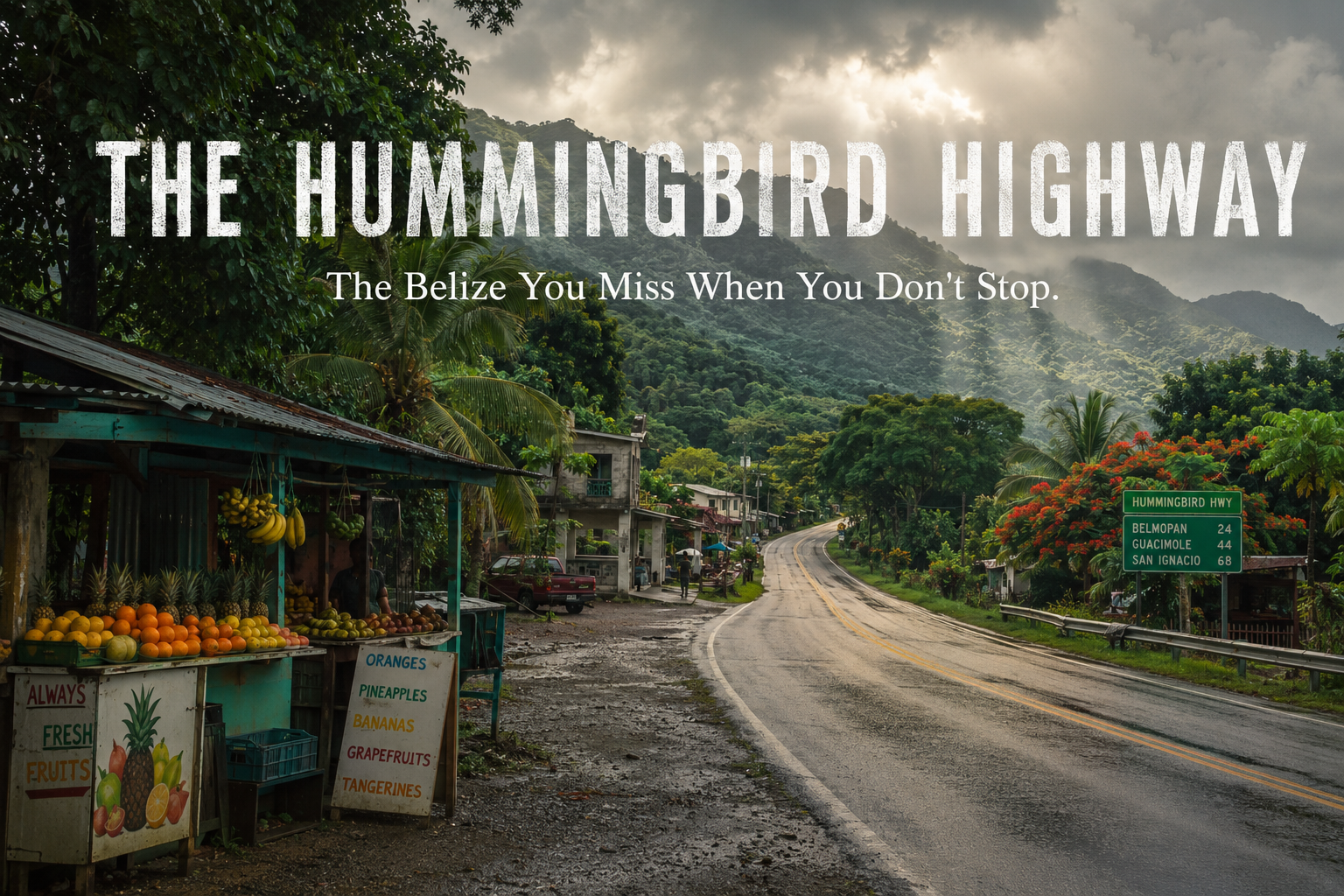
A fruit stand shows up.
Somebody remembers there is a swimming hole nearby.
Then a waterfall.
Then a cave.
Then somebody sells something beside the road that smells considerably more interesting than whatever snack you packed.
By the time you reach Dangriga, the highway has quietly turned itself into part of the vacation.
That is the Hummingbird Highway.
And if you drive it only as a way to get from Point A to Point B, Belize has several complaints.
Where Is the Hummingbird Highway?
The Hummingbird Highway connects the Belmopan area with Dangriga and southeastern Belize.
Travel Belize describes the scenic section as approximately 53.7 miles, or 86.42 kilometres, winding through mountains and agricultural landscapes before reaching the southeast.
From there, travelers can continue toward Hopkins, Placencia and farther south.
The Belize Tourism Board’s published road-distance guide puts Belize City to Dangriga at about 105 miles when traveling via the Hummingbird Highway, with Hopkins and Placencia farther beyond.
But mileage tells you almost nothing about this drive.
The interesting part happens between the numbers.
First, Belize Starts Folding Into Mountains
Belize can fool visitors.
Spend several days on the northern coastal plain or cayes and you may begin thinking you understand the landscape.
Flat.
Caribbean.
Palms.
Then head toward the Hummingbird Highway.
Suddenly the road begins threading between the foothills of the Maya Mountains.
The horizon changes.
Dense green vegetation presses toward the road.
During rainy season, everything becomes almost offensively green.
Clouds hang around the mountains.
Small communities appear and disappear.
And somewhere along the drive you realize the Belize from the beach advertisements has left the room.
Good.
There is more to see.
Stop One: Belmopan Before You Leave It
Most people treat Belmopan as a place to pass through.
Belize’s capital has never been particularly bothered by this.
It has government offices.
It has things to do.
It will survive your lack of enthusiasm.
But if you’re starting the drive around market day, Belmopan can be an excellent place to stock up on fruit, snacks and food before heading south.
Travel Belize particularly recommends the market on Tuesdays and Fridays, when vendors sell produce, prepared Belizean foods and local products.
This is an important road-trip principle:
Never begin a Belize drive assuming you’ll simply eat later.
Later has a habit of becoming why didn’t we buy tamales when we saw them?
Then Comes St. Herman’s Blue Hole
And no.
Not that Blue Hole.
Belize has created an ongoing tourism confusion by possessing two entirely different famous places involving blue water and holes.
The internationally famous Great Blue Hole is offshore.
St. Herman’s Blue Hole National Park is inland, along the Hummingbird Highway near Belmopan.
Inside the park are forest trails, caves and the cool blue swimming hole that gives the park its name.
The attraction is especially useful on a road trip because you can decide how ambitious you feel.
Want a swim?
Fine.
Want a walk?
Fine.
Want a cave?
Belize has noticed you becoming overconfident and can arrange that too.
St. Herman’s Cave Is More Than an Adventure Stop
We’ve talked about Belizean caves before, but St. Herman’s deserves attention in its own context.
Travel Belize identifies the cave as an important spiritual site during the Maya Classic Period and notes archaeological evidence including artifacts and calcified skeletal remains. Cave tubing is also available as an adventure experience.
Nearby Crystal Cave contains Maya archaeological material including pottery and ritual features amid extensive limestone formations.
So once again, the Belize cave rule applies:
You are not merely entering an interesting geological formation.
You are entering a cultural landscape.
Treat it accordingly.
Somewhere Around Here, Look Up
This is advice rather than an attraction.
Look up.
Put the phone down.
Unless you’re driving.
In which case please continue looking at the road; Stories of Belize accepts no responsibility for whatever happens because you were trying to photograph a mountain.
The Hummingbird Highway is one of those places where the space between attractions matters.
Mountain ridges.
Creeks.
Villages.
Roadside houses.
Agricultural land.
People waiting for buses.
Schoolchildren.
Football fields.
Laundry.
Dogs with apparently urgent highway-related responsibilities.
This is Belize too.
You don’t need an entrance ticket for it.
Five Blues Lake Is One of the Highway’s Strangest Stops
Then there is Five Blues Lake National Park.
Even the story sounds slightly unbelievable.
Travel Belize describes the park as an underrated attraction accessible around Mile 32 of the Hummingbird Highway, named for the different blue shades once visible in its lake. The surrounding forest and limestone hills support hiking, swimming and birding.
But the lake has another claim to fame.
It has drained and refilled unexpectedly over the years.
That makes Five Blues one of those places where the correct answer to:
“Why did the lake do that?”
is sometimes:
“We are still discussing it.”
Nature is allowed to keep a few secrets.
Billy Barquedier Requires a Little More Effort
Farther along the route, Billy Barquedier National Park protects 1,639 acres of tropical evergreen forest between the Mullins River and Stann Creek watersheds.
The payoff for visitors is particularly Belizean:
Walk through the forest.
Find waterfall.
Get in water.
Travel Belize describes the trail to the freshwater Barquedier waterfall as roughly a 15-to-20-minute hike from the park area.
This isn’t the giant polished attraction where a shuttle deposits 200 people beside a gift shop.
That’s part of the appeal.
But the Highway Isn’t Just Nature
This is where generic road-trip guides can get a little boring.
Waterfall.
Cave.
Viewpoint.
Photo.
Next.
The Hummingbird Highway also passes through one of Belize’s important agricultural landscapes.
Stann Creek has long been associated with citrus production, alongside other crops. Travel Belize describes the highway as winding through citrus orchards and banana-growing country toward the Caribbean coast.
That agriculture shaped livelihoods.
Communities.
Employment.
Food.
Industry.
The road isn’t simply cutting through pretty scenery.
It is passing through working Belize.
Stop at the Fruit Stand
Please.
You are in a tropical country driving through agricultural land.
This is not the moment to eat the granola bar you brought from Miami.
Look for what is actually in season.
Orange.
Grapefruit.
Banana.
Pineapple.
Mango.
Whatever somebody happens to have.
The exact selection changes throughout the year.
That’s the point.
Food tells you where you are in the calendar.
Ask what something is.
Ask how to eat it.
Ask whether it’s sweet.
And if a Belizean tells you:
“Try it.”
Understand that you have now entered into a binding cultural agreement.
Then Somebody Hands You Pepper Sauce
The Hummingbird Highway also passes through the country associated with one of Belize’s most recognizable food exports.
Marie Sharp’s began as a Belizean habanero-pepper enterprise and has grown into an internationally recognized brand.
Travel Belize includes the factory among its recommended Hummingbird Highway experiences and traces the company’s beginnings to Marie Sharp’s home kitchen in the early 1980s.
This is worth noticing because travelers often think of “local products” as handicrafts.
Food products are cultural exports too.
A bottle of Belizean pepper sauce sitting in somebody’s kitchen thousands of miles away is doing a small amount of storytelling every time somebody asks:
“Why is this so good?”
Roadside Food Deserves Its Own Stop
Do not make every meal a destination restaurant.
Some of the most useful travel advice Stories of Belize can give you is this:
Pay attention to where Belizeans are stopping.
Roadside eateries and food stalls along the Hummingbird route can offer tamales, rice and beans, stewed chicken, pastries, juices and other everyday Belizean foods. Travel Belize specifically highlights these smaller family-run and roadside food experiences as part of the drive.
The menu may not be twelve pages.
Excellent.
Sometimes the entire business model is:
This is what we cooked.
Would you like some?
Yes.
You probably would.
What About Davis Falls?
Davis Falls frequently appears on Hummingbird Highway itineraries.
Travel Belize describes it as a waterfall near Alta Vista Village and recommends it as one of the route’s more off-the-beaten-path adventures.
But this is where a responsible guide needs to make a distinction.
Something appearing “near the highway” does not mean you should casually turn off the road and improvise.
Road and trail conditions in rural Belize can change substantially with weather.
For more remote waterfalls and tracks, get current local information before going.
Your rental car’s optimism is not four-wheel drive.
The Highway Changes Again as You Approach Dangriga
Eventually the mountains begin giving way toward the coast.
The air changes.
The landscape changes.
And the road brings you toward Dangriga.
This is another reason the Hummingbird Highway is interesting.
It doesn’t simply connect two places.
It connects landscapes.
Central Belize.
Maya Mountain foothills.
Agricultural Stann Creek.
Garifuna cultural territory.
Caribbean coast.
By the time you reach Dangriga, the Belize you were looking at an hour earlier has changed.
Same country.
Different story.
Should You Drive the Hummingbird Highway Yourself?
For travelers comfortable driving in Belize, the route can make a fantastic self-drive road trip.
But this is not a road on which I would build an aggressively timed itinerary.
Weather matters.
Stops take longer than expected.
Road conditions can change.
You may find somewhere you want to stay.
You may eat.
Eating has consequences for schedules.
And some side attractions require more careful planning than simply turning off the highway.
If you’re visiting during rainy season, check current weather and local conditions before attempting remote roads, rivers or waterfall excursions.
The highway is beautiful.
It does not owe you punctuality.
How Long Should You Allow?
Google Maps will tell you how long it takes to drive somewhere.
Google Maps has apparently never met a Belizean road trip.
If you simply need transportation between Belmopan and Dangriga, fine.
Drive.
If you actually want to experience the Hummingbird Highway, give it at least half a day.
A full day is better if you’re including a meaningful park, cave or waterfall stop.
And an overnight somewhere along the corridor can turn the road from transportation into a destination.
This is especially true if you’re combining central Belize with Hopkins, Dangriga or Placencia.
The Best Stop Might Not Have a Name
This is perhaps my favorite thing about the highway.
Not every worthwhile place has a TripAdvisor page.
Sometimes the thing you remember is a roadside stand.
A mountain view.
A creek.
A tiny restaurant.
A conversation.
A village you hadn’t heard of.
A piece of fruit.
Rain moving over the hills.
A dog who clearly believed the road belonged to him.
The modern travel industry teaches us to move from attraction to attraction.
See this. Book that. Photograph this. Rate that.
The Hummingbird Highway rewards something else.
Attention.
Drive Slowly Enough to Notice Belize
There are faster ways to get south now.
Belize’s improved road network has changed how travelers move between Belize City and the southeast; the Belize Tourism Board’s published distances show the Coastal Plain/Coastal Highway route substantially shortening trips from Belize City to destinations including Dangriga, Hopkins and Placencia.
That makes the Hummingbird Highway even more interesting.
Because choosing it can increasingly become exactly that:
A choice.
Not merely the road you have to take.
The road you want to take.
For the mountains.
For the caves.
For the swimming holes.
For the fruit stands.
For the food.
For the villages.
For the waterfalls.
For all the Belize that happens between the places somebody told you were important.
So yes.
Go to Dangriga.
Go to Hopkins.
Go to Placencia.
But somewhere after Belmopan, resist the urge to ask:
“How much longer?”
Try another question.
“What are we passing?”
Because sometimes the best way to discover Belize is to stop treating the road like empty space between destinations.

Author: Tiffany Simpson
Tiffany Simpson is a Belizean writer and editor helping people turn lived experiences, personal histories and ideas into stories worth keeping. Her work explores the intersections of identity, culture and storytelling, with a particular interest in Belizean, Caribbean and African diasporic voices. Through Stories of Belize, she is building a cultural storytelling hub that documents the people, traditions, food and everyday experiences that shape Belize; at home and across the diaspora.